
Portal:Andes
The Andes Portal

The Andes (/ˈændiːz/ AN-deez), Andes Mountains or Andean Mountain Range (Spanish: Cordillera de los Andes; Quechua: Anti) are the longest continental mountain range in the world, forming a continuous highland along the western edge of South America. The range is 8,900 km (5,530 mi) long and 200 to 700 km (124 to 435 mi) wide (widest between 18°S and 20°S latitude) and has an average height of about 4,000 m (13,123 ft). The Andes extend from South to North through seven South American countries.: Argentina, Chile, Bolivia, Peru, Ecuador, Colombia and western Venezuela.
Along their length, the Andes are split into several ranges, separated by intermediate depressions. The Andes are the location of several high plateaus—some of which host major cities such as Quito, Bogotá, Cali, Arequipa, Medellín, Bucaramanga, Sucre, Mérida, El Alto and La Paz. The Altiplano Plateau is the world's second-highest after the Tibetan Plateau. These ranges are in turn grouped into three major divisions based on climate: the Tropical Andes, the Dry Andes, and the Wet Andes.
The Andes Mountains are the highest mountain range outside Asia. The range’s highest peak, Argentina's Aconcagua, rises to an elevation of about 6,961 m (22,838 ft) above sea level. The peak of Chimborazo in the Ecuadorian Andes is farther from the Earth's center than any other location on the Earth's surface, due to the equatorial bulge resulting from the Earth's rotation. The world's highest volcanoes are in the Andes, including Ojos del Salado on the Chile-Argentina border, which rises to 6,893 m (22,615 ft). (Full article...)
Selected articles
-

Pico El León is a mountain in the Andes of Venezuela. It has a height of 4740 metres. (Full article...) -
Monte Fitz Roy (also known as Cerro Chaltén, Cerro Fitz Roy, or simply Mount Fitz Roy) is a mountain in Patagonia, on the border between Argentina and Chile. It is located in the Southern Patagonian Ice Field, near El Chaltén village and Viedma Lake. It was first climbed in 1952 by French alpinists Lionel Terray and Guido Magnone. (Full article...) -
Cerro Castillo Dynevor, also known as Castillo Dynevor is located on the northwest coast of Skyring Sound, in Magallanes Region, Chile. It is named after its resemblance with Dynevor Castle in Wales, which was noticed by British explorers in 1830.
Its access is quite harsh due to the nature that all roads end about 30 km from it, and the rest of the way must be done either on a 4x4 vehicle, motorcycle, horse or on foot, either way the appropriate track is just by the shore, not through the woods, as they are too dense. (Full article...) -
Acotango is the central and highest of a group of stratovolcanoes straddling the border of Bolivia and Chile. It is 6,052 metres (19,856 ft) high. The group is known as Kimsa Chata and consists of three mountains: Acotango, Umurata (5,730 metres (18,799 ft)) north of it and Capurata (5,990 metres (19,652 ft)) south of it.
The group lies along a north–south alignment. The Acotango volcano is heavily eroded, but a lava flow on its northern flank is morphologically young, suggesting Acotango was active in the Holocene. Later research has suggested that lava flow may be of Pleistocene age. Argon-argon dating has yielded ages of 192,000±8,000 and 241,000±27,000 years on dacites from Acotango. Glacial activity has exposed parts of the inner volcano, which is hydrothermally altered. Glacial moraines lie at an altitude of 4,200 metres (13,800 ft) but a present ice cap is only found past 6,000 metres (20,000 ft) of altitude. (Full article...) -
Imbabura is an inactive stratovolcano in northern Ecuador. Although it has not erupted for about 7,500 years, it is not thought to be extinct. Imbabura is intermittently capped with snow and has no permanent glaciers.
Covered in volcanic ash, the slopes of Imbabura are especially fertile. In addition to cloud forests, which are found across the northern Andes to an altitude of 3000 m, the land around Imbabura is extensively farmed. Maize, sugarcane, and beans are all staple crops of the region. Cattle are also an important commodity, and much of the land on and around Imbabura, especially the high-altitude meadows above the tree line, is used for grazing. (Full article...) -
Nevado Juncal is a mountain at the border of Argentina and Chile, at the head of Aconcagua Val. It has a height of 5,953 metres (19,531 ft). It is located at La Yesera, Los Andes Department, Valparaíso Region, at the Central Andes. The mountain hosts several glaciers including the Juncal Norte and Juncal Sur. (Full article...) -
Tupungato, one of the highest mountains in the Americas, is a massive Andean lava dome dating to Pleistocene times. It lies on the Argentina–Chile border, between the Chilean Metropolitan Region (near a major international highway about 80 km (50 mi) east of Santiago) and the Argentine province of Mendoza, about 100 km (62 mi) south of Aconcagua, the highest peak of both the Southern and Western hemispheres. Immediately to its southwest is the active Tupungatito volcano (literally, little Tupungato), which last erupted in 1987.
Tupungato Department, an important Argentine wine-producing region in Mendoza province, is named for the volcano. Recent Chilean mapping indicates it has a height of 6635m. (Full article...) -
Sangay (also known as Macas, Sanagay, or Sangai) is an active stratovolcano in central Ecuador. It exhibits mostly strombolian activity. Geologically, Sangay marks the southern boundary of the Northern Volcanic Zone, and its position straddling two major pieces of crust accounts for its high level of activity. Sangay's approximately 500,000-year-old history is one of instability; two previous versions of the mountain were destroyed in massive flank collapses, evidence of which still litters its surroundings today.
Due to its remoteness, Sangay hosts a significant biological community with fauna such as the mountain tapir, giant otter, Andean cock-of-the-rock and king vulture. Since 1979, its ecological community has been protected as part of the Sangay National Park. Although climbing the mountain is hampered by its remoteness, poor weather conditions, river flooding, and the danger of falling ejecta, the volcano is regularly climbed, a feat first achieved by Robert T. Moore in 1929. (Full article...) -

The royal cinclodes (Cinclodes aricomae) is a Critically Endangered passerine bird in the Furnariinae subfamily of the ovenbird family Furnariidae. It is found in Bolivia and Peru. (Full article...) -
The vicuña (Lama vicugna) or vicuna (both /vɪˈkuːnjə/, very rarely spelled vicugna, its former genus name) is one of the two wild South American camelids, which live in the high alpine areas of the Andes, the other being the guanaco, which lives at lower elevations. Vicuñas are relatives of the llama, and are now believed to be the wild ancestor of domesticated alpacas, which are raised for their coats. Vicuñas produce small amounts of extremely fine wool, which is very expensive because the animal can only be shorn every three years and has to be caught from the wild. When knitted together, the product of the vicuña's wool is very soft and warm. The Inca valued vicuñas highly for their wool, and it was against the law for anyone but royalty to wear vicuña garments; today, the vicuña is the national animal of Peru and appears on the Peruvian coat of arms.
Both under the rule of the Inca and today, vicuñas have been protected by law, but they were heavily hunted in the intervening period. At the time they were declared endangered in 1974, only about 6,000 animals were left. Today, the vicuña population has recovered to about 350,000, and although conservation organizations have reduced its level of threat classification, they still call for active conservation programs to protect populations from poaching, habitat loss, and other threats. (Full article...) -
The Llao Llao Hotel is located in the tourist resort of San Carlos de Bariloche within the Río Negro, Argentina.
This famous hotel is situated in the foothills of the Andes on a hill between the Moreno Lake and Nahuel Huapi lakes. (Full article...) -
Tungurahua (/tʊŋɡʊˈrɑːwə/; from Quichua tunguri (throat) and rahua (fire), "Throat of Fire") is an active stratovolcano located in the Cordillera Oriental of Ecuador. The volcano gives its name to the province of Tungurahua. Volcanic activity restarted on August 19, 1999, and is ongoing , with several eruptive episodes since then, the most recent lasting from February 26 to March 16, 2016. (Full article...) -
Chungará is a lake situated in the extreme north of Chile at an elevation of 4,517 metres (14,820 ft), in the Altiplano of Arica y Parinacota Region in the Lauca National Park. It has a surface area of about 21.5–22.5 square kilometres (8.3–8.7 sq mi) and has a maximum depth of about 26–40 metres (85–131 ft). It receives inflow through the Río Chungara with some minor additional inflows, and loses most of its water to evaporation; seepage into the Laguna Quta Qutani plays a minor role.
The lake formed between 8,000 and 17,000 years ago when the volcano Parinacota collapsed and the debris from the collapse dammed the Lauca River. Since then the lake has progressively grown owing to decreasing seepage. The lake is part of the Lauca National Park; a planned diversion of the lake's waters into the Azapa Valley being abandoned after a decision by the Chilean Supreme Court. (Full article...) -
Rasac (possibly Quechua for toad) is a mountain in the Huayhuash mountain range in west central Peru, part of the Andes. It has a summit elevation of 6,017 metres (19,741 ft), although other sources cite a height of 6,040 metres (19,816 ft). Rasac is a long, relatively squat mountain on the western edge of the Huayhuash range, across the glacier from the tallest peak in the range, Yerupajá. Although it is a 6,000 metre mountain, Rasac's broad profile is dwarfed by Yerupajá. (Full article...) -
El Cocuy National Park is a national park located in the Andes Mountains within the nation of Colombia. Its official name is Parque Nacional Natural El Cocuy. (Full article...) -
Cayambe or Volcán Cayambe is a volcano in Ecuador, in the Cordillera Central, a range of the Ecuadorian Andes. It is located in Pichincha Province, some 70 km (43 mi) northeast of Quito. It is the third-highest mountain in Ecuador, at an elevation of 5,790 m (18,996 ft) above sea level.
Cayambe, which has a permanent snow cap, is a Holocene compound volcano which last erupted in March 1786. At 4,690 metres (15,387 ft), its south slope is the highest point in the world crossed by the Equator, and the only point on the Equator with snow cover. The ice cap covers an area of about 22 km2 (8 sq mi) and there are glaciers on the eastern flank descending to about 4,400 m (14,400 ft), whereas those on the drier western flank reach about 4,700 m (15,400 ft). The volcano and most of its slopes are within the Cayambe Coca Ecological Reserve. (Full article...) -
Sarapo is a mountain in the Huayhuash mountain range in the Andes of Peru, about 6,127 metres (20,102 ft) high. It is located in the Huánuco Region, Lauricocha Province, Jesús District as well as in the Lima Region, Cajatambo Province, in the districts Cajatambo and Copa. Sarapo lies south of the Yerupaja and the Siula Grande and east of the lake Sarapococha. (Full article...) -
Ritacuba Blanco is the highest peak of Cordillera Oriental, in the Andes Mountains of Colombia. It's also named Ritak'uwa, an ancient name from the U'wa indigenous people that live in the lowlands of the National Park Sierra Nevada del Cocuy y Güicán, where the Ritacuba Blanco is located.
The summit is accessible from the west via the town of El Cocuy, the village of Güicán, and the hamlet of Las Cabañas. The hike is fairly easy, but the weather is not reliable, and a glacier must be crossed.
Because of global warming, its glacier is melting at very high rates, backing down 25 linear mts per year; the same is happening at amazing speeds to all other snow-covered tropical mountains in Colombia. In 1950, Ritacuba Blanco's glacier extended down to 4,100 metres (13,500 ft) above sea level; in January 2007 its lowest point was at 4,500 metres (14,800 ft) above sea level. If this melting rate continues, the glacier is expected to disappear before 2055. (Full article...) -
Runtuy (Quechua for "to hail" or "to lay an egg") is a mountain in the eastern extensions of the Cordillera Blanca in the Andes of Peru which reaches a height of approximately 4,000 m (13,000 ft). It is located in the Ancash Region, Huari Province, Huari District, northwest of Huari. (Full article...)
-
Licancabur (Spanish pronunciation: [likaŋkaˈβuɾ]) is a stratovolcano on the border between Bolivia and Chile, south of the Sairecabur volcano and west of Juriques. Part of the Andean Central Volcanic Zone, it has a prominent, 5,916-metre (19,409 ft)-high cone. A 400–500-metre (1,300–1,600 ft) summit crater containing Licancabur Lake, a crater lake which is among the highest lakes in the world, caps the volcano. There are no glaciers owing to the arid climate. Numerous animal species and plants live on the mountain.
Licancabur formed atop of Pleistocene ignimbrites and has been active during the Holocene, after the ice ages. Three stages of lava flows emanate from the edifice and have a young appearance. Although no historic eruptions of the volcano are known, lava flows extending into Laguna Verde have been dated to 13,240 ± 100 BP and there may be residual heat in the mountain. The volcano has primarily erupted andesite, with small amounts of dacite and basaltic andesite. (Full article...) -
Cerro Galán is a caldera in the Catamarca Province of Argentina. It is one of the largest exposed calderas in the world and forms part of the Central Volcanic Zone of the Andes, one of the three volcanic belts found in South America. One of several major caldera systems in the Central Volcanic Zone, the mountain is grouped into the Altiplano–Puna volcanic complex.
Volcanic activity at Galán is the indirect consequence of the subduction of the Nazca Plate beneath the South America Plate, and involves the infiltration of melts into the crust and the formation of secondary magmas which after storage in the crust give rise to the dacitic to rhyodacitic rocks erupted by the volcano. (Full article...) -
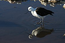
The Andean avocet (Recurvirostra andina) is a large wader in the avocet and stilt bird family, Recurvirostridae. It is resident in the Andes, breeding above 3500 m in northwestern Argentina, western Bolivia, northern Chile and southern Peru. (Full article...) -
Cerro Macá is a stratovolcano located to the north of the Aisén Fjord and to the east of the Moraleda Channel, in the Aysén del General Carlos Ibáñez del Campo Region of Chile. This glacier-covered volcano lies along the regional Liquiñe-Ofqui Fault Zone.
Cerro Macá is a relatively small volcano with a volume of only 39 cubic kilometres (9.4 cu mi). It has a summit elevation of approximately 2,300 m above sea level and features glaciers that in 2011 covered an area of 27.62 square kilometres (10.66 sq mi). The edifice is partially eroded and a sector collapse is probably the origin of a large steep sided depression in the summit area. Pyroclastic cones with associated lava flows are found on its southwestern flank but also on the other slopes of the volcano, as far down as sea level and in the Bahia Aysen. (Full article...) -

Tata Sabaya is a 5,430-metre (17,810 ft) high volcano in Bolivia. It is part of the Central Volcanic Zone, one of several volcanic belts in the Andes which are separated by gaps without volcanic activity. This section of the Andes was volcanically active since the Jurassic, with an episode of strong ignimbritic volcanism occurring during the Miocene. Tata Sabaya lies in a thinly populated region north of the Salar de Coipasa salt pan.
Volcanic activity at Tata Sabaya and elsewhere in the Central Volcanic Zone is the consequence of the subduction of the Nazca Plate beneath the South America Plate. The volcano has developed along a lineament that separates older crust north of the lineament from younger crust in the south, and the edifice has been formed by andesitic rocks. (Full article...) -
Falso Azufre is a complex volcano at the border of Argentina and Chile.
Falso Azufre is elongated in east–west direction and contains craters and lava domes; most craters have diameters of 300–600 metres (980–1,970 ft) with the exception of the main crater, which is 1 by 1.3 kilometres (0.62 mi × 0.81 mi) wide. The highest summit Cerro Falso Azufre lies at the western end in Chile, which has mostly generated pyroclastic material from craters. The probably youngest segment of the volcano is the eastern section in Argentina, where two lava domes and two cones are located; these form the Dos Conos volcano. Some lava flows linked to Dos Conos are up to 7 kilometres (4.3 mi) long. The oldest is known as the Kunstmann edifice on the northwestern side of Falso Azufre; Kunstmann volcano features a 3 kilometres (1.9 mi) wide scar formed by a sector collapse. Falso Azufre with a base surface of 387 square kilometres (149 sq mi) is one of the biggest volcanoes in the area. The presence of two oppositely curved vent alignments gives the complex an arc-like shape which reaches heights of about 5,900 metres (19,400 ft) above sea level. (Full article...)


.jpg)


.jpg)
Did you know...
- ... that the 1930s Polish Andean expeditions have been credited with several first ascents and the tracing of a new route to the summit of Aconcagua, the Andes' highest peak?
Need help?
Do you have a question about Andes that you can't find the answer to?
Consider asking it at the Wikipedia reference desk.
General images
-

-
 The seaward tilting of the sedimentary strata of Salto del Fraile Formation in Peru was caused by the Andean orogeny. (from Andean orogeny)
 -

-

-
 Map of the Andean region of South America (from Andean agriculture)
 -
 Ulluco: Common crop of the Andean region (from Andean agriculture)
 -
 A male Andean cock-of-the-rock, a species found in humid Andean forests and the national bird of Peru (from Andes)
 -
 Bolivian Andes (from Andes)
 -
 Parinacota, Bolivia/Chile (from Andes)
 -
 Mashua tubers (from Andean agriculture)
 -

-
 Pacha Mama Ceremony (from Andean agriculture)
 -
 View of Cuernos del Paine in Torres del Paine National Park, Chile (from Andes)
 -

-
 Paleogeography of the Late Cretaceous South America. Areas subject to the Andean orogeny are shown in light grey while the stable cratons are shown as grey squares. The sedimentary formations of Los Alamitos and La Colonia that formed in the Late Cretaceous are indicated. (from Andean orogeny)
 -

-
 Irrigating land in the Peruvian Andes (from Andes)
 -
 Laguna de Sonso tropical dry forest in Northern Andes (from Andes)
 -

-
 Pico Humboldt at sunset (from Andes)
 -
 Frederic Edwin Church, Heart of the Andes, 1859. (from Andes)
 -
 Syncline next to Nordenskjöld Lake in Torres del Paine National Park. The syncline formed during the Andean orogeny. (from Andean orogeny)
 -
 Map of a north-south sea-parallel pattern of rock ages in western Colombia. This pattern is a result of the Andean orogeny. (from Andean orogeny)
 -
 Topographic map of the Andes by the NASA. The southern and northern ends of the Andes are not shown. The Bolivian Orocline is visible as a bend in the coastline and the Andes lower half of the map. (from Andean orogeny)
 -

-
 Central Andes (from Andes)
 -
 Simplified sketch of the present-situation along most of the Andes (from Andean orogeny)
 -

-
 Aerial view of Valle Carbajal in the Tierra del Fuego. The Andes range is about 200 km (124 mi) wide throughout its length, except in the Bolivian flexure where it is about 640 kilometres (398 mi) wide. (from Andes)
 -

-
 Peruvian farmers sowing maize and beans (from Andes)
 -
 Nevado del Huila, Colombia (from Andes)
 -


.jpg)

.jpg)


.JPG)
.jpg)


%E2%80%93Valle_Carbajal_01.jpg)


.jpg)

Subcategories

- Select [►] to view subcategories
Related portals
Subtopics
Associated Wikimedia
The following Wikimedia Foundation sister projects provide more on this subject:
-
 Commons
Free media repository -
 Wikibooks
Free textbooks and manuals -
 Wikidata
Free knowledge base -
 Wikinews
Free-content news -
 Wikiquote
Collection of quotations -
 Wikisource
Free-content library -
 Wikiversity
Free learning tools -
 Wiktionary
Dictionary and thesaurus


